Learn › Before the flight › Weather Information for the Preflight Decision
Weather Information for the Preflight Decision
A briefing is not paperwork you complete before the flight — it is the flight's first decision. The skill is turning a screen of abbreviations into a go or no-go you can defend.
Preflight Preparation — FI.III.C
Why the briefing is a decision, not a formality
Under 14 CFR 91.103 the pilot in command must, before beginning a flight, "become familiar with all available information concerning that flight" — and for a flight not in the vicinity of an airport the section goes on to name weather reports and forecasts explicitly. Read 91.103 itself rather than any paraphrase of it, this one included: the CFR is the authority, and it changes.
The rule sets a floor. The reason to do it properly is that weather rarely refuses you all at once. Fog forms quietly overnight and may not lift for hours after you expected it to. Ceilings settle a few hundred feet at a time. The VFR pilot trapped below minimums usually did not fly into a wall — they flew into a gradual change that had been forecast, and that they did not look up.
A briefing is a process, not a phone call. You can get one from Flight Service or self-brief from approved sources, which AIM 7-1-2 and AC 91-92 describe. Either way the output is the same: not a printout, but a decision with the reasons still attached to it.
Where the weather comes from
The National Weather Service produces the official forecasts, warnings, surface analyses, radar and satellite, and its Aviation Weather Center is the NWS office that packages the aviation-specific products at aviationweather.gov — METARs, TAFs, AIRMETs, SIGMETs, the GFA. So the first two are one agency, not two. Flight Service at 1-800-WX-BRIEF adds a briefer who filters that same data for your route. Apps redisplay the government products, and ATIS, ASOS and AWOS give you the field's conditions right now.
Watching apps in the days beforehand is general awareness, not a decision, and it does not substitute for the detailed briefing on the day. If you call Flight Service, identify yourself as a pilot and give the briefer:
- Type of flight — VFR or IFR
- Aircraft number, or your name, and aircraft type
- Departure airport, route and destination
- Flight altitudes
- ETD and ETE
The shape of a briefing
AIM 7-1-4 lists what a standard briefing contains, and the order is deliberate — what can stop the flight comes first. Adverse conditions lead. Next comes "VFR flight not recommended", said aloud when VFR flight is doubtful in the briefer's judgment: it is advice rather than a prohibition, and it is the one item on a marginal day you should never quietly talk yourself past. After that the synopsis, current conditions, the en route forecast, the destination forecast, winds aloft, NOTAMs and ATC delays, with more available on request. Read the section for the current list. A self-brief lays out the same material with nobody saying it out loud, which leaves the judgment where it was always going to sit anyway. The headings below group those items the way you will work through them.
Adverse conditions
TFRs are issued for security and special events; check the effective times and altitudes, not just the circle on the map. SIGMETs cover non-convective weather hazardous to all aircraft — severe icing not associated with thunderstorms, severe or extreme turbulence including clear air turbulence not associated with thunderstorms, dust or sandstorms lowering surface visibility below three miles, and volcanic ash. They are unscheduled and generally valid four hours, except that SIGMETs for tropical cyclones and volcanic ash may be valid up to six; AIM 7-1-6 carries the criteria and the valid periods, and is the text to check. Convective SIGMETs cover the storms: severe thunderstorms, embedded thunderstorms, lines of thunderstorms, or thunderstorms producing heavy precipitation affecting 40 percent or more of an area of at least 3,000 square miles.
AIRMETs come every six hours, amended as needed, and are aimed at what matters to light aircraft: Sierra for IFR conditions and mountain obscuration, Tango for turbulence, strong surface winds and low-level wind shear, Zulu for icing and freezing levels. PIREPs are the only product written by someone who was actually there — cloud tops, icing, turbulence, the height of a layer between reporting stations. An urgent PIREP (UUA) means a tornado, severe or extreme turbulence, severe icing, hail, wind shear within 2,000 feet of the surface, or volcanic ash.
Reading the hazards is the easy half. The work is matching each against the airplane's capability and your own, for each segment separately. A ceiling that is fine at the destination is not fine if it sits over the pass you planned to cross.
Synopsis
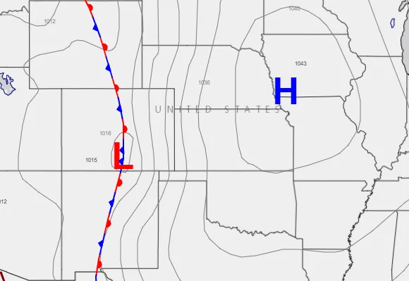
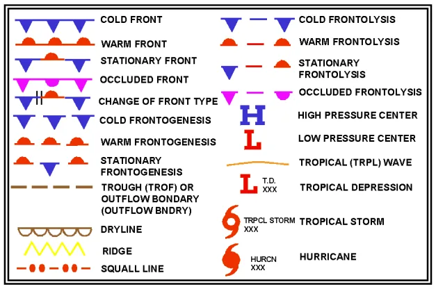
The surface analysis chart, prepared every three hours, is the big picture: highs, lows, troughs and ridges, and the fronts between air masses. Closely spaced isobars mean a steep pressure gradient and strong wind. Air sinks and spreads outward from a high, which is why highs bring fair weather; air converges and rises into a low, which is why lows bring cloud and precipitation. The arrival of any front means the weather is about to change.
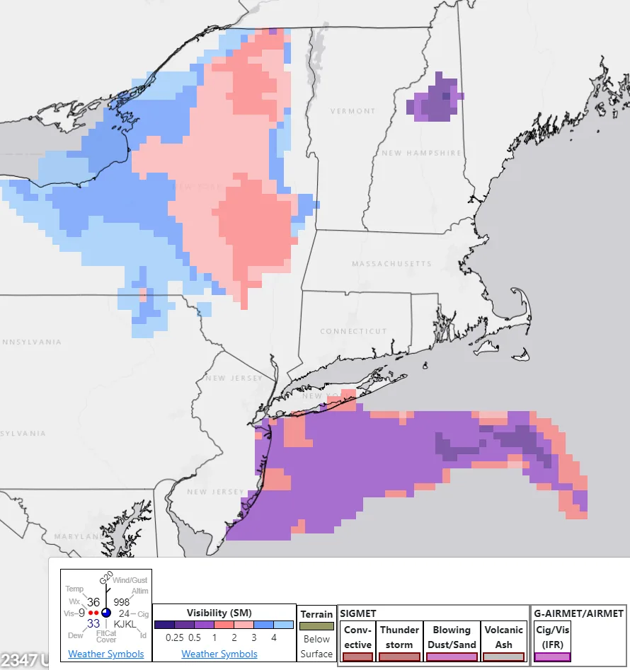
The Ceiling and Visibility Analysis adds where VFR, MVFR, IFR and LIFR conditions exist right now — current conditions, not a forecast, and never a substitute for the TAF.
Current weather
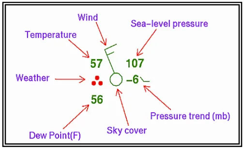
The METAR is issued hourly, generally in the last ten minutes of the hour, and is valid until the next one. A SPECI comes between them when something significant changes: visibility or ceiling crossing a defined threshold, precipitation or thunderstorms starting, stopping or changing intensity, a wind shift of 45 degrees or more in under fifteen minutes with sustained winds of 10 knots or more. A string of SPECIs is information in itself — that airport is not stable. Read temperature and dewpoint as a pair, too: a small and closing spread is the earliest warning of fog or a lowering ceiling, and the same spread run through cloud base gives you a height to expect the convective bases at. If the format is still slow, decoding METARs drills it until it reads as a sentence rather than a code.
Forecasts
The TAF forecasts conditions within five statute miles of an airport. The four routine issuances carry valid periods beginning 0000Z, 0600Z, 1200Z and 1800Z, and each is transmitted roughly 20 to 40 minutes before its period starts — the times are the start of the forecast, not the moment it was written. Its change groups are where the forecaster records what is uncertain: FM for a rapid change at a stated time, BECMG for a gradual one, TEMPO for conditions expected briefly or intermittently, and PROB30 or PROB40 for a 30 or 40 percent chance, which are the only two probability groups a TAF carries and are not used in the first nine hours of the forecast period. Do not read past them to the part of the forecast you liked.
The Graphical Forecast for Aviation fills the gap the TAF leaves — the en route portion, and everywhere without a TAF — running from roughly fourteen hours in the past to eighteen ahead, covering clouds, flight category, precipitation, icing, turbulence and wind. The winds and temperatures aloft forecast picks your cruise altitude, and its temperature column helps place the freezing level, with one gap worth knowing: no temperature is forecast for the 3,000 foot level, or for any level within 2,500 feet of station elevation, and no winds are forecast within 1,500 feet of station elevation. Low down, which is exactly where a trainer meets ice, the column you wanted is blank, and the freezing level has to come from the GFA, an AIRMET Zulu or a PIREP instead. Icing needs visible moisture and an airframe at or below freezing, so setting the freezing level against the forecast cloud layers shows whether your route hands you both at once. The convective outlook grades areas from general thunderstorms up through marginal, slight, enhanced, moderate and high risk.
NOTAMs
D NOTAMs carry airport and facility information — the closed runway, the unlit tower, the out-of-service navaid. FDC NOTAMs are regulatory, and that is where TFRs and changes to instrument procedures live. Both stay valid until canceled or until their published end time, and both need checking along the route, not only at the departure field.
What none of it can tell you
Every product has an edge. A METAR describes one point at one airport, and an automated station reports only what its sensors see. A TAF stops at five miles. Forecasts are probabilistic — a 30 percent chance of thunderstorms promises nothing either way. And the radar mosaic on a datalink display can be older than its timestamp suggests, which makes it a strategic tool for going around a system and never a tactical one for threading between cells.
Making the call
Run the whole picture through PAVE — pilot, aircraft, environment, external pressures. Weather is only the environment leg; your recent experience and, more honestly, your proficiency sit on the other side of the same decision.
Personal minimums are the thresholds you set above the legal ones: a higher ceiling and visibility than the regulations require, a firmer crosswind limit than the day's demonstrated component, no flight into forecast icing or turbulence. Write them down before you are standing at the airport with somewhere to be, and do not bend them on the day. The point is that they were set when nothing was pushing you.
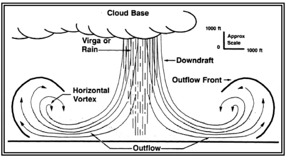
Thunderstorms can end a flight plan on their own. AIM 7-1-27 is where the avoidance guidance lives and is worth reading in full; the distance it states, at least 20 miles, is attached to any thunderstorm identified as severe or giving an intense radar echo, and it is stated in miles. Holding that same 20 miles off anything convective is a personal minimum rather than a rule, and it is a good one to keep. Treat a line of storms as something a light airplane neither circumnavigates nor climbs over, and remember that the microburst beneath one produces downdrafts and headwind losses well beyond what a trainer can climb out of.
The decision is continuous, not a single gate at the FBO door. It runs through planning, through the preflight, and through every update you get en route. Reduced visibility, hazardous weather along the route, an urgent PIREP where you were going, or anything below your own minimums are reasons to turn back or divert — which is not planning failing, but the plan working.
Where you meet it next
On the checkride, weather is a Preflight Preparation task, and no examiner accepts a recitation of what the products are. You are handed real weather for the cross-country you planned and asked what it means, what you cannot tell from it, and what you would do about it. The answer that passes is specific: this layer, this freezing level, this alternate, this personal minimum. Each product here has a lesson behind it in the weather series — stability and cloud formation, fronts and air masses, icing, and thunderstorms — and the codes get their own drill in decoding METARs. The numbers a briefing hands you become performance in the next task along: field elevation and temperature through density altitude, the altimeter setting through pressure altitude.
Figures