Learn › Technical subjects › Navigation Systems and Radar Services
Navigation Systems and Radar Services
Pilotage tells you where you think you are. These systems tell you whether you were right — and give you somewhere to fall back to when you were not.
Technical Subject Areas — FI.II.H
Why you carry more than a chart and a watch
Dead reckoning asks you to be right about the wind, right about the clock, and right about which lake you are looking at. Navigation systems check that judgment, and radar services put a second set of eyes on your airplane. The goal is not dependence on one box. It is fluency in several, so losing one is an inconvenience rather than an emergency.
VOR: two signals and the angle between them
A VOR transmits two signals. One is a reference signal, identical in every direction. The other is a variable signal whose phase changes as it sweeps around the station. Your receiver measures the difference between them, and that difference is your radial — your magnetic bearing from the station, somewhere in the 360 degrees around it.
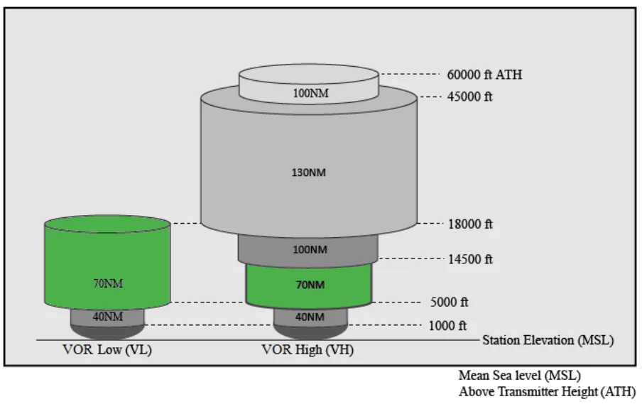
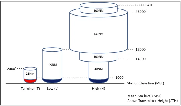
VORs work on VHF, 108.0 to 117.95 MHz, which explains their main limitation: line of sight. Terrain blocks the signal and so does the curve of the earth, so the lower you fly the less range you have. How much range you get depends on the station's service volume — the legacy Terminal, Low and High classifications, plus newer VOR Low and VOR High volumes added to support en route RNAV. You do not memorize the shapes; you look the station up in the Chart Supplement and check NOTAMs before planning a leg around a VOR that may be out of service.
Using one
A VOR receiver is a radio, so every radio habit applies. Tune, identify, monitor. Tune the frequency, confirm the Morse ident so you know you are receiving the station you think you are, and keep listening — a station taken off the air stops sending its ident before your needle does anything dramatic. Then center the needle with a TO indication, turn to that course, and crab for wind. The course selector shows what you asked for; the needle shows whether you are on it. Neither knows your heading.
Checking the receiver
A receiver can drift out of alignment with the station it is reading. Checks are not required for VFR, but they are the only assurance that the radial your box displays matches the radial the station sent. Four ways to do it: an FAA VOT facility, a certified airborne checkpoint, a certified ground checkpoint on an airport surface, or a dual VOR cross-check between two receivers in the same airplane. Checkpoints are listed in the Chart Supplement. For IFR use, 14 CFR 91.171 sets the interval, the logging and the tolerances, including ±4 degrees on the ground and ±6 degrees airborne. The CFR is the authority and it changes; read the current text of 91.171 rather than a number you remember.
When the needle stops making sense
Work it in order. Check what you programmed, check the frequency is the one you meant, then twist the course knob and find the radial you are actually on. A poor signal is often fixed by climbing, because line of sight is an altitude problem. If it is gone entirely, fall back — GPS, moving map, the window, ATC. Losing a navaid is only a loss of situational awareness if you had nothing else running.
NDB, ADF and DME
An NDB radiates in every direction and the ADF needle simply points at it. Being low frequency it is not limited by line of sight, but it is badly affected by thunderstorms and electrical disturbance, which produce static, needle swings and fading. Its worst quality is that it gives no warning when the bearing is wrong — a noisy or absent ident is the only clue. To turn the needle into a bearing: magnetic heading plus relative bearing equals magnetic bearing. MH + RB = MB, and if the sum runs past 360 you subtract 360.
DME pairs a UHF channel with the VHF frequency of a VOR/DME or VORTAC. Your airplane sends a pulse, the station replies, and the receiver times the round trip. What you get is slant range — straight-line distance to the station, not distance across the ground. Directly overhead at altitude it reads your height rather than zero. The error shrinks the farther out and lower you are, but it is real when you are high and close.
GPS
GPS has three segments: space (the satellites), control (the ground stations that track and correct them), and user (your receiver). Satellites broadcast their position and a timestamp; your receiver listens and solves for where it must be. It does not talk back. The United States guarantees 24 operational satellites at least 95 percent of the time. Three in view give a two-dimensional position; four give latitude, longitude and altitude.
RAIM — receiver autonomous integrity monitoring — is how the box decides whether the signals are good enough to navigate on. It compares satellites against each other and looks for one that disagrees. Detecting a fault takes five satellites; detecting it and excluding the bad one, fault detection and exclusion, takes six. RAIM can be unavailable, and predicted outages are worth checking through the FAA's Service Availability Prediction Tool before you go.
WAAS corrects for known GPS errors. Ground stations at surveyed locations compare what GPS tells them against where they actually are, a master station turns the differences into corrections, and geostationary satellites relay them to your receiver — accurate enough to fly vertically guided approaches on.
Every GPS carries a navigation database of waypoints, airways, airports, navaids and procedures, and many carry obstacle and terrain databases behind the terrain alerting. They run on a 28-day cycle. An expired database does not fail loudly; it quietly navigates you to something that moved. Check the effective date.
Radar service for VFR pilots
ATC radar exists primarily to separate IFR traffic, but a VFR pilot who asks gets real service from it: safety alerts for terrain, obstructions and other aircraft, traffic advisories, limited vectoring, and sequencing where that is established. All of it is workload permitting, and the answer is sometimes no.
Two things do not change when you accept it. Radar service does not relieve you of pilot-in-command responsibility, including see and avoid. And it is not a substitute for a weather briefing. Controllers do help: AIM 7-1-13 has them providing weather avoidance assistance and information on precipitation their equipment can see, workload permitting. That is assistance around what shows up on their scope, not a picture of the weather along your route, and it is not the briefing you owe yourself before departure.
Ask early, before you are already inside the airspace you want help with, and give the controller everything in one transmission — who, where, altitude, destination, request. "Salt Lake Approach, Wolf 99, three miles west of Provo at 6,500 climbing to 8,500, headed to Tooele, requesting flight following." The cruise altitude in that call is doing work. The course is roughly 300 degrees magnetic, and 14 CFR 91.159 governs VFR cruising altitudes more than 3,000 feet above the surface, putting a magnetic course of 180 through 359 degrees on even thousands plus 500. Flight following does not change that, and neither does a controller's silence about it. Read 91.159 for the current wording; the CFR is the authority and it changes.
Transponders and ADS-B
Radar sees you by interrogating your transponder and reading the reply. Mode A returns a squawk code only, Mode C adds pressure altitude, Mode S adds data exchange. Codes run 0000 to 7777 — octal, which is why there is no 8 or 9 on the knob. 1200 is the VFR code in the United States: you set it before you taxi, you leave it there unless ATC assigns you a discrete code, and you go back to it when radar service ends. Three more you set without being asked:
- 7500 — hijack
- 7600 — lost communications
- 7700 — emergency
ADS-B is automatic dependent surveillance — broadcast. Automatic because it sends without being interrogated, dependent because it depends on GPS for the position it sends. ADS-B Out broadcasts your position, altitude and velocity to ATC and to other aircraft.
Where it is required is set out in 14 CFR 91.225, and that section, not a summary of it, is what you plan against. It reaches further than most pilots carry in their heads: Class A, Class B and Class C; the airspace above the Class B and Class C shelves up to 10,000 feet MSL; Class E at and above 10,000 feet MSL except the airspace below 2,500 feet AGL; the Gulf of Mexico above 3,000 feet MSL within 12 nautical miles of the coast; and the one people miss, 91.225(d)(2) — the airspace within 30 nautical miles of a Class B primary airport from the surface up to 10,000 feet MSL, the Mode C veil. Under that veil there is no shelf to duck beneath. Twenty-five miles out at 1,500 feet AGL, clear of every ring of the Class B, you are still inside the veil and 91.225 still applies. Read the current section before you plan around it; airspace text gets amended.
ADS-B In is voluntary, and what it gives you depends on which link you are receiving. 978 UAT In receives FIS-B, the weather uplink — that is where the free radar, METARs and TAFs on a tablet come from. 1090ES In receives traffic and no weather at all, because FIS-B is broadcast only on the 978 MHz link. Out works the same way: 1090ES ADS-B Out is built into a Mode S transponder, while 978 UAT uses a separate transmitter.
The traffic picture has a condition attached to it too. TIS-B, which is radar-derived traffic, and ADS-R, which rebroadcasts traffic from the other link, are client-based services: the ground station uplinks them only when a properly equipped ADS-B Out aircraft is inside the service volume to trigger them. A receive-only airplane with no participating client nearby can sit under a display that is close to empty while other airplanes are genuinely there. So the display is not merely imperfect — it can be quiet for reasons that have nothing to do with the traffic. It supplements the scan; it does not replace it.
Staying ahead of the automation
You are responsible for using all of this correctly. Nothing formally requires an EFB, but carrying one means keeping its charts current and knowing what it can and cannot do. An autopilot stops earning its place the moment you are watching it and wondering why — disconnect, fly, diagnose afterward. Underneath all of it is attention: aviate, navigate, communicate, in that order, and when you are behind the airplane, say so.
Where you meet it next
On a checkride this is a knowledge task: describe at least one ground-based navigation system, then satellite-based navigation — which is GPS, including RAIM and database currency — then radar services and what each transponder mode reports. Expect the follow-ups. What is one limitation of a VOR. Do your GPS receivers talk to the satellites. How does a VFR pilot use radar services.
In the airplane, you meet it every time the plan and the airplane disagree about where you are. Keep two systems running and the surprise stays small.
- Decoding METARs — the reports FIS-B pushes to the tablet, and how to read them before you trust them
- Pressure altitude — the altitude Mode C and ADS-B Out actually report
- the other lessons here
- The kneeboard — charts, weather and ADS-B traffic on the tablet
Figures